


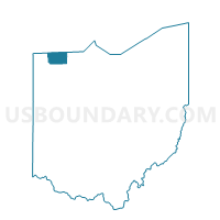
CHESTERFIELD, Fulton County, Ohio
About
Outline

Summary
| Unique Area Identifier | 646570 |
| Name | CHESTERFIELD |
| County | Fulton County |
| State | Ohio |
| Area (square miles) | 29.10 |
| Land Area (square miles) | 29.00 |
| Water Area (square miles) | 0.10 |
| % of Land Area | 99.65 |
| % of Water Area | 0.35 |
| Latitude of the Internal Point | 41.67937150 |
| Longtitude of the Internal Point | -84.16370240 |
Maps


Graphs
Select a template below for downloading or customizing gragh for CHESTERFIELD, Fulton County, Ohio


Neighbors
Neighoring Voting District (by Name) Neighboring Voting District on the Map
- Voting District 0912702000001, Lenawee County, MI
- Voting District 0915550000001, Lenawee County, MI
- Voting District 0917244000001, Lenawee County, MI
- DOVER, Fulton County, OH
- FRANKLIN, Fulton County, OH
- GORHAM, Fulton County, OH
- PIKE, Fulton County, OH
- ROYALTON, Fulton County, OH
Top 10 Neighboring County Subdivision (by Population) Neighboring County Subdivision on the Map
- Gorham township, Fulton County, OH (2,260)
- Morenci city, Lenawee County, MI (2,220)
- Pike township, Fulton County, OH (1,854)
- Fairfield township, Lenawee County, MI (1,764)
- Dover township, Fulton County, OH (1,578)
- Royalton township, Fulton County, OH (1,515)
- Seneca township, Lenawee County, MI (1,230)
- Chesterfield township, Fulton County, OH (1,012)
- Franklin township, Fulton County, OH (743)
Top 10 Neighboring Place (by Population) Neighboring Place on the Map
Top 10 Neighboring Unified School District (by Population) Neighboring Unified School District on the Map
- Wauseon Exempted Village School District, OH (10,371)
- Pike-Delta-York Local School District, OH (7,989)
- Evergreen Local School District, OH (7,578)
- Morenci Area Schools, MI (4,303)
- Fayette Local School District, OH (2,599)
Top 10 Neighboring State Legislative District Lower Chamber (by Population) Neighboring State Legislative District Lower Chamber on the Map
Top 10 Neighboring State Legislative District Upper Chamber (by Population) Neighboring State Legislative District Upper Chamber on the Map
Top 10 Neighboring 111th Congressional District (by Population) Neighboring 111th Congressional District on the Map
Top 10 Neighboring Census Tract (by Population) Neighboring Census Tract on the Map
- Census Tract 408, Fulton County, OH (4,940)
- Census Tract 405, Fulton County, OH (4,899)
- Census Tract 619, Lenawee County, MI (4,583)
- Census Tract 406, Fulton County, OH (4,430)
- Census Tract 620, Lenawee County, MI (2,897)